
Adobe
Just about anywhere you go in New Mexico, you will find crumbling adobe ruins. They speak of a time when the pace of life was more relaxed, more sane. I have photographed hundreds of these ruins over the years. These are just a few of my favorites.
 I have photographed this adobe wall several times. It is tucked away in a small northern New Mexico village. I love the layers on this wall, the peeling paint, the crumbling stucco, the eroded adobe, and then there’s the weathered wooden slats and peeling plywood.
Nikon DF, Nikkor 24-70 f2.8 @42mm, 1/500 sec, f8
 This rock/adobe house is tucked away in a village not far from where I live. I’ve driven past it thousands of times, but I never noticed it (hidden back off the road as it is). When I did finally see it it had a visual impact on me and I made this image.
Nikon DF, Nikkor 80-200 f2.8 @150mm, 1/80 sec, f10
 In eastern New Mexico there are many small communities that are just hanging on. They boomed during the 50s and 60s when many people were driving the Mother Road, US 66. Today they are but ghosts of their former selves. I found this old pink adobe in one of those villages.
Nikon DfF, Nikkor 24-70 f2.8 @35mm, 1/640 sec., f10
 I was attracted to the colors and textures in this scene. The house is located on a two lane highway in north-central New Mexico, but the small town was pretty much deserted
Nikon DF, Nikkor 24-70 f2.8 @50mm, 1/160 sec, f5
If you are interested in purchasing a print of one of the images in this post, just click on the image and you will be directed to that image’s page on my website.
Share this:

Nostalgic Tableau

In my travels around New Mexico in search of photographs to document the disappearing culture that once thrived here, I have come across many pleasant surprises. This is one of them.

I was down along the Rio Grande in central New Mexico and found myself in a small village that has a fair share of adobe ruins. Exploring inside one of them, I found this old shirt hanging on a carved door. The window panes have been replaced by wood panels, but the scene caught my imagination and I was suddenly transported forty or fifty years into the past in the presence of the long gone inhabitants.
Share this:

Windmills
I made this photograph a couple years ago while camping in cental New Mexico. I made several wider angle versions, but I like this tighter one.
 The juxtaposition of the old ranch windmill and the windfarm on the mesa caught my eye as I was driving through an old abandoned settlement. I much prefer the more organic look of the old wooden one.
Share this:

The Writing On The Wall

The title of this post may be somewhat deceptive. Most of us think of writing on the wall as actual markings of some kind made by man (or woman) for the purpose of communicating something to others. And, while a couple of the images included here do feature pictographs and petroglyphs, Most do not. Instead, they are images of natures writing.
 This pictograph is on a wall about a quarter mile from my home. It is on the side of a state road, but most people who drive by it are unaware of its presence. Like most drawings of this sort, the meaning is unclear, and lost to the ages but someone in the distant past felt the need to scribe these images onto this rock.
 This canyon wall and talus slope is located along the Green River near Hardscrabble Bottom in Canyonlands. I was attracted to the contrast between the rock wall and the living tamarisk as well as the no longer living cottonwood tree. I love the desert varnish on the sandstone and the beginning erosion of what will one day probably be an amphitheater.
 This cross-bedded sandstone near the Escalante River in southern Utah speaks for itself. Its story spans ages, and now it is revealed as a work of art millions of years in the making.
 These petroglyphs are in the backcountry of Monument Valley. They are called the Eye of the Sun Petroglyphs because of their proximity to an arch bearing that name. It is perhaps someone’s tale of the animals he came across that day, or perhaps a boastful recounting of the game he had killed.
 These young aspen trees are growing against a sandstone wall which is covered with lichen. The combination creates a tapestry in which the trees reflect the stains on the wall and overlay them with a filigree of branches.
 Here is another example of cross-bedded sandstone. I made this photograph while kayaking with my daughter and her husband in the Apostle Islands on Lake Superior. The colors of the stone combined with the intersecting fracture lines, the lichen, and the small, but tenacious, plants caught my eye almost immediately.
Share this:

Far Flung Curiosities
In my travels photographing the roots of my home state, I have travelled mostly the two lane blacktops, what William Least Heat Moon called blue highways because that was how they were shown on maps. The back roads of New Mexico often bring surprises, things that are unexpected, things that fire the imagination. I have included a few of these treasures here. There are countless others out there waiting to be rediscovered.
 This road grader sits in a yard behind a gabien/rail fence. It was owned by a friend of mine who died several years ago. He was a good man, a hard working man who did not tolerate fools. When I saw it with the falling snow I made this image without much thought other than of the technical aspects.
 The Ayers Family built this house from a kit sold by Sears in the 1920s. Now it sits slowly deteriorating near Estancia, NM. I wanted a somber, brooding sky to emphasize the haunted look of the place. The two dead trees complete the picture and the feel of decay. While making this image, I felt the ghosts of the place not far from the surface.
 This building, an old neighborhood bar, sits on the edge of a small village in the Rio Grande Valley. From the outside, it doesn’t look like much. I was drawn to it because I noticed the tree growing inside, but I was not expecting the eye; it seemed so out of place. Looking closely, it appears as though it has been there for quite a while. Whatever its origin, it adds an eerie presence to the scene. I shot through the opening to frame the interior and to reflect the shape of the opening in the far wall. This also has the effect of preserving the secret hidden within.
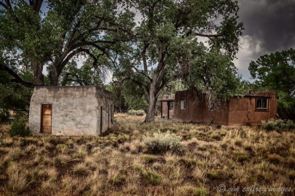 In the early days of the Manhattan Project, a woman named Edith Warner was living in a small house along the Rio Grande where the one lane Otowi Bridge crossed the river giving access to the Pajarito Plateau and Los Alamos. She often hosted the scientists and dignitaries who worked at and visited the site. The house on the right was her residence and the small building on the left was the tea house where she served many people over the years including friends from nearby San Ildefonso Pueblo.
 I was on a one lane dirt road near the Rio Grande Gorge when I came upon this 1940 something Chevy pickup buried to its wheel wells in the sandy earth. There was not a single soul that I had seen within a mile of the place. After I finished photographing, I had my lunch while sitting on the fender enjoying the solitude.
 I photographed this church in Taiban, NM long before it became a destination for social media photographers. I looked for quite a while for the right composition and finally settled on this head-on perspective with the dead shrubs in the foreground. They seemed to fit the mood of the moment and the lonely desolation of the scene.
 I was about as far off the beaten track as you can get, even for central New Mexico. The windmill lying by the side of the road seemed bigger that it would look in its accustomed place: high on a tripod along a single track ranch road. It was November, so the trees were in various stages of decline; I would not not have made this image in the spring or summer when the trees were leafed out.
Share this:

Relics of the Mother Road
Along the route and at road’s end, the decay of man’s dreams and the simple elegance of the natural scene have been the premier attraction. The pattern of dunes, the color of sheet metal, the weathering of wood, and the changing sky are images that are as important to me as the ‘grand view’.
John Kiewit; from the preface to Gone to Sanctuary from the Sins of Confusion
As I mentioned in a previous entry, I have been travelling around the state making images of a decaying way of life. A project and a journey inspired by a book. I wish I could have known John Kiewit, I think we would have had a lot to talk about..
 Cuervo, New Mexico straddles what is now Interstate 40. In Cuervo’s heyday, it was Route 66. This deteriorating frame house is in the section of the town that sits on the south side of the freeway. I was drawn to make this photograph by what remains of the cedar shake shingles on the roof. As with most of the photographs I have made for this project, I shot the subject straight on. I think of these images as a hybrid of objective documentary and subjective, expressive photographs.
 The rusty, scavenged hulk of a car is as common in the rural New Mexican landscape as crumbling adobe. This one–I believe it’s from the 50s or early 60s– was parked near a small, completely abandoned village in Eastern New Mexico. There are many of these disappearing places and eroding vehicles along what was once “The Mother Road”.
 I made this image in a small town that like many in that part of New Mexico is mostly a ghost town. The old picket and wire fence overgrown with weeds makes a perfect foreground for the faded pink wall and the glassless window. The rusted cans on the sill speak of former inhabitants, now long gone. I included just a little of the corrugated roof to provide contrast to the wall. As with most of my images, I made several versions, most of them wider views of the entire house, but I like the intimacy of this one.
 I long ago outgrew the desire to use my camera as a Xerox machine. Standing amidst a throng of people with cameras on tripods to bag a “trophy shot” holds no attraction for me. That being said, when I saw a photograph by John Mulhouse of this quirky, timeworn truck parked in front of a now defunct resturant in Tucumcari, I knew I had to make my own photograph of it.
 I love the mottled look of the adobe on this house. The rusty corrugated tin roof creates tension. The curtained windows led me to suspect inhabitants, but there were no other signs of anyone living there. I wandered through this town for more than an hour and talked with one resident, but he confirmed that most of the residents were gone elsewhere.
 This steel suspension bridge over the Rio Puerco no longer carries traffic. I can remember crossing it while on a road trip with my young family back in the eighties and, further back, I probably rode over it as a hitchhiker in the late sixties. Now it stands playing an uncertain role between the freeway and the frontage road. It’s been disignated a historic bridge and is on the national registry; the small, dented, rusting sign on the western end of the bridge tells us so.
![]() Early spring and the elms and cottonwoods were leafing out. I was on a part of old route 66 that still has a few towns that are relatively well populated. As I drove through this village, I spotted this shuttered service garage. It is right on the main drag, but no one was around to fill me in on its history. I stayed there for a while because it felt like someone could walk out the door at any second. My patience was not rewarded.
Early spring and the elms and cottonwoods were leafing out. I was on a part of old route 66 that still has a few towns that are relatively well populated. As I drove through this village, I spotted this shuttered service garage. It is right on the main drag, but no one was around to fill me in on its history. I stayed there for a while because it felt like someone could walk out the door at any second. My patience was not rewarded.
 This sunlight reflecting off the broken windshield drew my attention to this old rusty chevy. It was parked back off the road between two buildings. I had to wait for the sun to move so the glare was off the glass. There is something poetic about these old vehicles, something almost natural about the rust and the paint and the shattered glass.
 I was actually back off the highway several miles when I came across this old adobe ruin. The vigas still sit on the walls, but the roof has long since given way to decay and gravity. It’s a small dwelling that harkens back to a time when quality was more important than quantity. It’s fortunate that I made this photograph in early spring; the elm tree was still pretty bare which, I think, suits the image.
Share this:

Postcards From Home
After more than a week of unfulfilled promises from the weatherman, and several half-baked attempts, we finally got a substantial snowfall here in northern New Mexico. So, I awoke in the pre-dawn of the new year to find a foot of fresh snow and more coming down.
 I made this image of my home from the southern boundary of my property. The rincon along the edge of Virgin Mesa is just visible through the falling snow to the north. I made several compositions and settled on this one. My main concern during the processing was to preserve the ethereal quality of the light through the snow on the distant rim.
Nikon Df, Nikkor 24-70mm f2.8
 I call it the Number 10 Cabin, but it’s really just an old barn/shed. I have photogrphed it many times over the years–it is located a couple hundred yards from my house. This image was made, obviously, during a snowstorm. I love to photograph in these conditions; the world seems to shrink down to just the elements within the frame. I used a relatively fast shutter speed to freeze the falling snow, which gives the photograph an almost pointillist feel.
Nikon Df, Nikkor 24-70mm f2.8
 This river runs through my land. I made this photograph from a wooden bridge located just north of my house. Normally when photographing moving water, I use a slow shutter speed to smooth the flow, but on this cold, snowy morning, freezing the movement with a fast shutter felt like the best way to portray the scene.
Nikon Df, Nikkor 24-70mm f2.8
 South of the village, the canyon opens up and the bosque has room to breathe. These cottonwoods on the edge of a small meadow stood out againt the low clouds. The world was reduced to the immediate surroundings. As I said previously, these are my favorite conditions to work in. Again, I used a fast shutter to freeze the falling snow, which adds another dimension to the image. I made another exposure using a slow shutter to mask the snow and this version is by far my favorite.
Nikon D810, Nikkor 24-120mm f4
 You can feel the silence and the mystery of the winter forest in this image. The trunks of Ponderosa Pine and Fir trees seem to go on forever and the veil of frozen air in the low clouds adds to the effect. I used a long lens to compress the separation between the trees. The sliver of snow covered ground at the bottom of the frame is essential to the composition; without it the image becomes more abstract.
Nikon D810, Nikkor 80-200mm f2.8
Share this:

Doorways
Doorways are often used as a metaphor for life: oopurtunities, events, seasons. They are usually spoken or written. But, in the context of this article, they are visual.

I made this photograph in 2012. At that time, I was spending a lot of my time exploring a particular area in northwestern New Mexico. My intent when I released the shutter was to say something about impermanence, more specifically the slow erosion of the adobe buildings which were built and inhabited by people whose way of life disappeared long ago. This doorway–which no longer exists–is an metaphor for that irrevocable past.
Nikon D700 Nikkor 16-35 f4 F22 1/10 ISO 100

At one time, this hall was full of children going about the business of aquiring an education. Now it is empty and decaying. While I was making this image, I closed my eyes and tried to imagine the bustle of its former life. I often do this while photographing abandoned buildings or ruins; it helps me to better understand my subject.
Nikon Df Nikkor 24-120mm f4 F10 1/60 ISO 400

Inevitably, the constructs of man give way to nature when left unattended. This adobe ruin with a tree growing in the entry is a good example. The colorful grafitti provides a visual as well as a metaphorical contrast to the scene.
Nikon Df Nikkor 24-120 f4 F8 1/320 ISO 400

While I was preparing to make this image I considered moving the tire out of the picture, but in the end, I left it in place. It serves as both a visual and a symbolic element. It is important to take the time to think about what you intend to say with a photograph if you want it to be more than just a representation of the scene.
Nikon Df Nikkor 50mm f1.4 F8 1/250 ISO 400
Share this:

New Directions
This is my first post in more than a year and a half, but that doesn’t mean I haven’t been busy. In fact I travelled and photographed more in 2020 than in the previous three years combined. What has changed is my approach to my photography and the subject matter. First of all, I have commited the ultimate sin for a landscape/nature photographer: I have pretty much left my tripod at home; most of the photographs I have made in the past two years have been shot handheld using a Nikon Df along with an assortment of lenses. As for the subject matter, I have been attempting to capture the detritus of a disappearing culture in a way that makes it pleasing to the eye.

This first image is of a quirky fence in the village of Cerrillos. I liked the way the winter weeds contrast the hard edged outline of the fence slats and the way the fence itself mimics the Ortiz Mountains in the distance.
Nikon Df, Nikkor 24-120mm f4 F11 1/640 ISO 400

This roadside tableau caught my eye as I was driving along a two lane blacktop in northern New Mexico. Actually, I made the first version in the spring when the leaves were green and new, but the image didn’t have the feel I was looking for, so I returned in the fall and got it right.
Nikon Df Nikkor 24-120 f4 F8 1/100 ISO 800

Most small rural villages in New Mexico have more than their share of abandoned homes and buildings which are slowly melting into the landscape. The broken window and the off-kilter door draw the eye to the reflection of the dead tree.
Nikon Df Nikkor 24-120mm F7 1/160 ISO 400

The shirt hanging on a carved door in a crumbling adobe is a bit eerie and, at the same time gives this image a human touch. I have come across several scenes like this in my travels and they always make me wonder about the lives of the people who called those places home.
Nikon Df Nikkor 50mm f1.4 F4 1/500 ISO 800

This last photograph is one of my favorites. The missing window pane, the tattered curtain, the broken stucco are all given a sense of hope (and a splash of color) by the blooming trumpet vines.
Nikon Df Nikkor 24-120mm F8 1/80 ISO 400
Share this:

Shipwreck-Low Tide

The Peter Iredale ran aground in heavy fog while trying to enter the Columbia River channel in October of 1906. The wreckage is still there today just west of the small town of Warrenton. The day I showed up to photograph the wreck, the conditions were just right. The thick overcast created a somber setting; all I had to do was wait for low tide so I could position the breaking waves where I wanted them in the image and capture the reflection and wave patterns in the wet sand.
I used my Nikon D810 with a Nikkor 24-120 f4 lens mounted on a Bogen-Manfrotto tripod. Post processing was done in Adobe Lightroom and Adobe Photoshop. Black and white conversion was done in Silver Efex Pro.
Share this:

Winter
At last, a real winter! One we denizens of the Jemez Mountains can be proud of. We’ve had two substantial snowfalls within the past two weeks, and there is more in the forecast. The day after Christmas I awoke to a world of swirling white. I quickly got dressed and grabbed my gear. There is nothing like being cloaked in the clouds during a fresh snowfall to bring the world into focus.

Jemez Springs has become a “destination”, the road and the village are typically busy with tourists, so it was a welcome relief to see it relatively abandoned with clean, new snow covering the small cluster of buildings that comprise the heart of the village. Luckily, the road hadn’t even been plowed yet.

The Jemez Historic Site (the pueblo of Giusewa) is about halfway between the village and my home. I have been wanting to make this image for quite a while, but due to a lack of the white stuff, I had put it off. This was my chance, and I think I made the most of it. This is what I consider to be the best of a series of seven exposures I made of this scene.

Continuing up the road, I came to Soda Dam. I have made many photographs of Soda Dam over the years; it’s only a five minute walk from my house. With the snow still coming down, I decided to give this image the same treatment as the one of the village seen above. I used a relatively fast shutter speed of 1/250th of a second to freeze the motion of the falling snow. The resulting image puts the tableau in context and serves to convey what I was feeling at the time I released the shutter.

After leaving the Soda Dam, I continued north on the highway into the Santa Fe National Forest. The most striking scenes I found were the ones of areas of forest burned in recent wildfires, their branches covered and defined by the snow. They provided a visual as well as a thematic contrast, and the photographs are a combination of realism and the abstract.
Share this:

Fallen Roof Ruin
Sometimes a cherished memory starts with a rumor. I had heard of several ruins lying not quite forgotten in the serpentine canyons of Cedar Mesa in southeastern Utah. It was while researching one of them that I discovered another, less well known, but no less visually compelling.

Fallen Roof Ruin,which is actually a group of granaries, is located in Road Canyon which meanders in a, more or less, easterly direction from it’s head, in the heart of Cedar Mesa, to it’s final destination in Comb Wash. The single element that sets it apart from the numerous other ruins in Road Canyon is the staining in the roof of the alcove in which the ruin is located. A large section of the ceiling has fallen, leaving exposed white stains–most likely from minerals in the groundwater which leeched from the mesa top–that are painted across the newly exposed strata.

The hike to the ruin is just under two miles. The trail crosses the mesa top for about a half-mile before dropping over the edge into the upper reaches of Road Canyon. The descent is about one-hundred-fifty feet, and then the trail follows the canyon bottom pretty much staying in it’s watercourse. There is some rock-hopping involved along with some route-finding in the places where the trail leaves the drainage to make it’s way around some of the bigger boulders in the path.

I was not quite prepared for the impact of being in that place. There is something about the essence of these ruins that set them apart from other ruins I have visited. So, as is the case with all of my photography, I attempted to reveal at least a part of the soul of this extraordinary place through my compositions and processing. The large slabs of stone scattered across the floor of the alcove serve to tell some of the story; they are also useful as compositional elements in the images.

One of the most poignant pieces of this nearly thousand-year-old tableau is the presence of several hand pictographs above the entry to one of the small granaries. These were probably made by placing a hand on the stone and then blowing a powdered dye through a reed. Hand pictographs are common in the ruins of the desert southwest, and are thought to be a way of saying: “I was here”.
Share this:

Roaming The San Juan Basin-Part 2
My previous post: Roaming The San Juan Basin-Part 1, was about the first day of a two-day road trip through the expanse of a great bowl shaped depression in the middle of the Colorado Plateau in northwest New Mexico. I spent Saturday night in Farmington and awoke early on Sunday. I had planned to head straight home from there, but as I prepared to leave, I thought better of it and decided to do some more exploring. As I drove up the road that leads from Farmington to the edge of the basin, I began to formulate a plan. I decided that I would avoid any of my normal haunts: the Bisti Wilderness, Ah Shi Sle Pah, etc. and that I would try to stay on dirt or gravel roads as much as possible. With this blog post in mind, I also decided to take a photojournalistic approach to making my images as opposed to my usual process.

Abandoned dwellings in the San Juan Basin west of Ah Shi Sle Pah
I left the paved road about forty miles south of Farmington and immersed myself in the rolling, broken landscape. The San Juan Basin has numerous drainages of all sizes that carve the washes and valleys that form the irregular surface and expose the long buried geological features. I turned south on a road I knew would take me past Ah Shi Sle Pah…forbidden territory on this trip. I noticed three abandoned dwellings off to the west. The walls were of rock; the roofs, non-existent or barely there. They had a melancholy look to them; it was as though they were being swallowed by the great expanse that surrounded them.

Wild horses along the southern edge of Ah Shi Sle Pah Wash
A few miles further along the road, I saw a band of horses; one group of seven animals, and a mare and foal off by themselves. I stopped the car and walked to the side of the road to set up my tripod and the larger cluster immediately moved farther away from me. I made a few exposures and decided I would try to get closer, but the horses ran to the edge of the wash while the closest one–a stallion and probably the alpha–stood his ground and began to snort and pound the ground with his hoof. From this behavior, I surmised that this was a wild band; the tame horses I have encountered are typically friendly and will even approach to within an arm’s length.

Tame horses in the San Juan Basin north of Kimbeto Wash
I took the hint and returned to the car. I didn’t want to alarm the animals any more than I already had. I didn’t make it more than a half mile further when I spotted a smaller group of three white horses on the south side of the road. These were more friendly, but still more stand-offish than usual. They continued their grazing, but were wary of my presence.

A ceremonial hogan in the San Juan Basin about twenty-five miles northwest of Chaco Canyon
Now I dropped down into Kimbeto Wash, a key drainage for this part of the San Juan Basin. I came to a tee in the road; to the left, Ah Shi Sle Pah, to the right, unknown territory. I turned right and crossed Kimbeto Wash. Less than a quarter mile further along was a road to the left and a sign: Chaco Canyon miles. The mileage was illegible. Onward.
I was excited to find a back way into Chaco; connecting the dots on a map has always been satisfying for me. The road crossed a grassy plain with a low mesa on the southern horizon. The only other visible feature was a lone hogan about a hundred yards off the road to the west. After about ten miles there was a sharp left turn and the track dipped down and crossed Chaco Wash before continuing up to the top of a high plateau.

An abandoned Navajo homestead just north of the Chaco River in the San Juan Basin
By now, I was firmly into a spontaneous wandering frame of mind; I took a turn onto a two-track that seemed to lead to the plateau’s edge, but the road curved back and dead-ended at an abandoned homestead, complete with old cars and trash burn barrels. I’ve seen hundreds of these forlorn dwellings scattered across the remote desert areas I frequent. They always put me in a pensive mood.
Back on the main road, I soon came to an intersection that put me on the main road into Chaco Canyon. I decided to make a quick tour of the loop.

Kivas at Chetro Ketl, the second largest pueblo in Chaco Canyon
One of the most interesting elements of the ancient pueblo culture for me is the kiva. There are different kinds of kivas: many were used as places for social gathering, but most of them were ceremonial in nature. These adjacent kivas at Chetro Ketl–the second largest pueblo complex in Chaco Canyon–were used for religious ceremonies. Standing near these centuries-old subterranean enclosures made me feel connected to the ones who contrived and built these amazing communities.

Pueblo Bonito is the largest pueblo in Chaco Canyon
Chaco Canyon is actually comprised of many pueblo complexes which were built over a span of four centuries and housed thousands of permanent residents and visitors from outlying sites. Of these complexes, Pueblo Bonito is the largest with more than eight hundred rooms. Like most of the pueblos in Chaco Canyon, Pueblo Bonito is built close against the wall of the mesa.

Pueblo del Arroyo lies right on the edge of the Chaco River
A little further along the loop road from Pueblo Bonito is Pueblo del Arroyo. It is situated along the edge of Chaco Wash and had three hundred rooms; it is thought to have been built by residents of Pueblo Bonito who moved due to overcrowding in the larger site.

Fajada Butte was used by the ancients to chart the passing of the seasons
I had already spent more time at Chaco Canyon than I wanted to, so I made for the exit that brought me to Hwy 57 heading south. As I passed the boundary I stopped to make a photograph of Fajada Butte which rises 440 feet above the canyon floor and is home to the most famous of all the Chaco sites: The Sun Dagger site. Three slabs of rock are set up and arranged in such a way that shafts of sunlight shine through them and onto specific parts of a petroglyph carved on the rock wall of the butte on each of the solstices and eqinoxes. More proof that these early Americans were far more advanced than the “savages” they have been depicted to be.

New Mexico state road 57 about ten miles south of Chaco Canyon
So, with these thoughts bouncing around in my head, I left Chaco behind and continued my exploration of the San Juan Basin. New Mexico State Road 57 is not what you might expect from the designation. Soon after it starts at US 550 between Huerfano and Nageezi, it sheds its asphalt coat and becomes a dirt road in the truest sense of the word. A good rain will quickly turn it into a quagmire of greasy clay, the kind that will defeat even the most serious four-wheel drive vehicle.

A playful mare on NM state road 57 south of Chaco Canyon
So, although I truly enjoy a good thunderstorm, I couldn’t help but hope that the building thunderheads would hold their water at least until I made it to the pavement of Indian Rte. 9 twenty-five miles to the south. I was about half way between Chaco and the paved road when over a rise in the road came two beautiful horses. One of them, a mare, turned sideways in the road and seemed to be bowing to me. I was enchanted; I spent over half an hour with them and when I finally left them behind, it was with some reluctance.

Horses water at a water barrel near the intersection of NM state road 57 and Indian Rte. 9
The remainder of the drive on NM 57 was relatively uneventful. There were a few small clusters of hoodoos and several small herds of livestock and then, suddenly I was at the intersection with the paved road. I looked back the way I had come, again with some reluctance, and then turned onto Indian Rte. 9. Almost immediately I came across three horses drinking from a water barrel. The scene seemed to say a good deal about the nature of this remote area, so I made a photograph of it.

An abandoned homestead along the road between Torreon and San Luis, New Mexico
After its intersection with NM 57, Indian Rte. 9 climbs onto a low mesa and emerges at Pueblo Pintado, an outlier of the pueblos at Chaco Canyon. This area is still inhabited by the descendants of the anasazi people, but now they live in houses scattered across the mesa in the shadow of the ruin that was their ancestral home. Another thirty miles brought me to Torreon. It is here that IR 9 becomes New Mexico 197 and turns northeast towards Cuba, NM. I turned onto an un-numbered, but paved road that runs from Torreon to the small village of San Luis in the Rio Puerco Valley. I passed a rock ruin that I had photographed before, but I stopped to make several exposures before continuing on towards San Luis.

A storm passes over Cabezon Peak seen here from the road between Torreon and San Luis, NM
As I drew near San Luis and the Rio Puerco Valley, a heavy thunderstorm passed ahead of me, nearly obscuring the volcanic monolith of Cabezon Peak. It seemed a fitting end to my adventure. Even as I neared home my mind began wandering and wondering about another dirt road I had noticed meandering into the vastness of the San Juan Basin…
Share this:

The Intentional Image
I am a photographer, I consider myself an artist. I don’t want to take pretty pictures. I strive to make moving images. A deep green reservoir and a late winter storm moving across distant mesas,

or a lone tree trapped in its winter slumber while light dances on a faraway butte, I had an emotional response to these encounters. As a photographer and an artist, I want to capture not just the way these things appear, but the way these things feel. For me, the making of an image does not stop after the shutter is released. I am not one of those photographers that proudly proclaim that they only strive to capture the image the way it was; total objectivity and nothing less.

Art is not objective. By its very nature, it must be more than that. The artist attempts to convey a certain feeling to those who view his work. This can only be achieved by making an image that is more than just a representation of a scene. To do this requires what some condescendingly call “manipulation”. I call it creating the image and I will make no apologies for that.
Imagine a watering hole miles from any village or human activity. Now imagine a bovine visitor that plods through the dry, cracked, yet still soft earth that lines the edges of the oasis. The sky is overcast and the light, while soft, still shapes the edges of the cracks and lends a beautiful glow to the surface of the moving water.

In order to make these things tangible within the constraints of a two dimensional photographic image, some work must be done beyond the framing, composition, and exposure that make up the original capture. There must be some intention to the final outcome
There are many circumstances where I am challenged to make an image that is different from those that came before. From an oft viewed roadside scene to a sudden ethereal display of atmospheric magnitude, the real challenge is not just to capture a technically acceptable representation of that scene or phenomena, or to use some cliche template to compose it, the challenge is to render it in a way that is unique to my vision.

By doing so, I hope to evoke some response to my work, to kindle in the viewer an appreciation of the world beyond the pavement where they may never have been, or where they may have been, but have never really seen.

In one of his contributions to Eliot Porter’s book “The Place No One Knew: Glen Canyon On The Colorado”, Frank Waters wrote: “We measure minutes, the river ignores millennia.” And, although he was referring to the Colorado River, we can still make the same statement about any river. They carve and shape the lands they flow through not judging or playing favorites, and at times they provide a striking contrast to the arid environment that borders their banks.

The Rio Chama is such a river. It makes its way through north-central New Mexico flowing past some remote, but memorable scenery along the journey to its confluence with the Rio Grande. If you throw in just the right amount of foreboding skies and ethereal light, the scene becomes magical. It is my job to capture that magic and to cause those who view my image to be drawn in by it, to wonder what may lie beyond that bend. I hope I have succeeded.
Share this:

Just Up (Or Down) The Road
I live in a wondrous place. The problem I have is that, being surrounded by beauty has made me a little thick-skinned; I guess you could say that I take it all for granted. So, I am putting my thoughts down in words accompanied by images, not so much to convince anyone else, but to remind myself.

Fenton Lake is a small (less than 40 acres) manmade lake which was formed by construction of an earthen dam on the Rio Cebolla. The Cebolla itself is not really a river by most standards; it is, at most, three feet wide along most of its length. But, here in New Mexico, it qualifies. I made this image on a dark day. I was standing amongst the cattails at the north end of the lake. The ridge line to the southeast burned during the Lake Fire in 2002.

One of the most recognizable and well known features in the Jemez Valley is Battleship Rock. It is composed of rhyolite and was formed when the volcano that shaped the present-day Jemez Mountains erupted for the final (hopefully) time, the ash and lava flowed into a box canyon; when it cooled the rock filled the canyon and as the softer earth eroded away, the monolith was left exposed.

Jemez Springs is a small village (population: 250) that lies in the heart of San Antonio Canyon–the canyon formed by the Jemez River. Not much has changed, visually anyway, since I first came here in 1977. This is a typical mid-week, January evening.

New Mexico Highway 4 runs through San Antonio Canyon for about thirty miles before climbing onto the flanks of the Valle Grande and continuing across the mountain to Los Alamos (yes that Los Alamos: home of the atomic bomb). This stretch of the highway is about five miles south of Jemez Springs.

In the early years of the last century, there was an extensive logging operation in the Jemez Mountains. The logging company used a train to haul the logs to a mill in Gilman. They bored two tunnels through the solid granite that transects the Guadalupe Box and when the logging declined, the tracks were replaced by a road–New Mexico SR 485–which provides access to the Santa Fe National Forest. Some may recognize the tunnels from the role they played in the film “3:10 To Yuma”

The Jemez River cuts through Soda Dam, a large, seven thousand year old calcium carbonate formation left behind by a small, unassuming hot-spring next to Highway 4. It is located about three hundred yards from my door and is a huge tourist attraction as well as being the swimming hole for local youngsters.

The second image provides a better view of the river flowing through the “dam”, and of the swimming hole; the kids jump from the sides into the plunge pool. When the New Mexico Highway Department blasted through the formation to improve Highway 4, the building process was interrupted, and the dam has been eroding since then.
Share this:

Eyes On The Stars
If you drive west from Socorro, New Mexico on US 60 about fifty miles, you will find yourself on the Plains Of San Augustin. The plains are about sixty miles long and ten to fifteen miles in width and were formed by Lake San Agustin during the last ice age. They lie between the San Mateo Mountains to the east and the Tularosa Mountains to the west. At first not much catches your eye, just flat grassland. But as you drive farther along, you begin seeing things that really don’t belong in the middle of a dry Pleistocene lake bed.

Scattered across the flat terrain are groupings of large dish antennae, the scene looks like something out of a science-fiction movie. In fact it was in a science-fiction movie. Much of the movie “Contact”, which was based on Carl Sagan’s book by the same name, was filmed at the Karl G. Jansky Very Large Array. And while, in the movie, the main focus of the array was to search for extraterrestrial intelligence, that is not really what scientists at the VLA are engaged in. Instead, they use the antennae to investigate astronomical features of galaxies and stars. The array was instrumental in communicating with Voyager 2 as it flew by the planet Neptune, and much of what we know about black holes, quasars, pulsars, supernovas… is because of observations made at the VLA and other installations like it around the world.

The VLA consists of twenty-eight antennae which are each twenty-five meters in diameter; twenty seven of them are online and working while one goes to the maintenance shed for…well, maintenance. The rest are arrayed along three tracks that are configured in a Y shape with each leg of the Y being thirteen miles long. When the antennae are set in their widest array, they, collectively, constitute a dish which is twenty-two miles in diameter. The individual antennae can be rearranged to suit the needs of the scientists using them. It depends on where, in the universe, they want to look.

To move the massive dishes (each one weighs 203 metric tons), technicians use special trains with pivoting wheels. The trains move along a double rail that follows each leg of the Y to pre-set positions where the train is raised, the wheels pivoted, and the train lowered onto the side tracks, then the dish is placed onto piers and bolted down. The last step is to re-attach all the servo and data cables to make the dish operational. As one can imagine, setting up a new configuration is a time consuming task requiring several days to complete.

Once all the dishes are in their new locations, operators at the Array Operations Center located on the campus of the New Mexico Institute of Mining and Technology in Socorro set the dishes to the correct azimuth and altitude so the scientists can make the observations they need.

The sight of these immense dishes spread across the plain, all looking in the same direction leaves me spellbound every time I see it. I am reminded of the vastness of the universe and of our place in it. The VLA site is a little off the beaten path, but it’s well worth the trip for anyone who looks up at the stars and wonders.
Share this:

My Few Of My Favorite Things
Wow! Another year fades into memory. I have spent the last couple weeks editing the images I’ve made in 2013 with the goal of culling my favorite dozen. Image editing for me is a labor of love; I have a connection to my work, so picking “the best” out of hundreds candidates is not an easy task.

I knew from the time I made this photo of a bull elk in my yard on January 3rd that I was setting a high standard for the rest of the year. Also, not only was it serendipitous, but the image was a departure from my usual wide angle landscapes. I had been feeling for some time that my work had been stagnating, so I resolved then and there to take it in a new direction.

In early February, I ventured into an area along US 550 that I had been looking at as a shooting location for some time. I was drawn by some red sandstone pinnacles that were visible from the highway. As I walked toward them, I came across this old section of road that is slowly eroding, being reclaimed by natural forces. The scene made me realize how impermanent our impact on nature really is. In the end, this is the image that stood out above the others I made that day. Again: serendipity.

As the year progressed, I found myself revisiting some places I had been before. The image of the church on San Ildefonso Pueblo (a scene I had driven past countless times before) is more about the light than the subject matter. It is also a more visually compressed image than is usual for me due to my use of a longer focal length lens.

Every year at the end of May–Memorial Day Weekend to be exact–the Pueblo of Jemez hosts the Starfeather Pow Wow. Hundreds of native dancers from across the country come to dance and compete. I made hundreds of images that weekend, but this portrait of two brothers stood out. They are dressed in “dog soldier” head-dresses, hair-pipe breastplates, and feather bustles, all made by their father. Just before I released the shutter, I told them to give me some attitude. I think they did a pretty good job.

Anyone who is familiar with my work, knows that I spend a great deal of time in the Rio Puerco Valley. It was near the middle of July and the rains had just started after several months of searing heat and cloudless skies when I made this image. There are many possible causes for this animal’s demise, but the location of its desiccated remains along a now rain-filled wash and the rain falling from a heavy sky tells an ironic story about the uncertainty of life in this harsh environment.

And speaking of harsh environments, the Bisti Wilderness in July can be a sobering place. The temperatures can soar to well over 100°F. I usually try to discourage clients from booking a photo tour during this time, but if the monsoons have started, it can be relatively pleasant and the cloudy skies lend a sense of drama to the scene. I made this image of one of my clients pondering the maze in the Brown Hoodoos section of the wilderness.

From a land of parched earth to a place where water is omni-present; my travels took me to Wisconsin in August. On a day-trip to Olbricht Botanical Gardens with my daughter, I made this image of the Thai Pagoda. Normally I steer clear of this kind of symmetry in a photograph, but the structure, and the entire environment seemed to demand it.

Autumn is the best time to be in the badlands, especially if the atmosphere cooperates. Even though the ground was soft and the washes were running from the rain, there were still cracks in the earth. It was as though the soil had a memory of the scorching it normally receives and refused to let go. After processing this image, I realized that it was best to convert it to black and white.

During the months of September and October I spent a great deal of time photographing the trains of the Cumbres-Toltec narrow-gauge railroad which runs from Chama, New Mexico to Antonito, Colorado. I spent every weekend for nearly a month chasing the trains and the fall colors. In the end, my favorite image had nothing to do with color and everything to do with the train, the track and the trestle.

To most people, in the US anyway, November means thanksgiving. For me it is my annual trip to Bosque del Apache National Wildlife Refuge. Over the years, I have come to relish my time with the cranes, herons, geese, and other waterfowl that call the Bosque home during the winter months. Even though I have thousands of images of the birds flying, taking wing, landing, wading, eating, and doing whatever else it is that they do, I still managed to make two of my favorites there in 2013.

This first is obvious and familiar: a crane in the process of taking off from one of the ponds to fly to the fields where he will spend the day foraging. The second is a departure from my normal Bosque images, but one that illustrates the reason that I keep returning year after year.

In December I travelled by train to visit my oldest daughter (an adventure I wrote about in my previous blog entry). Chicago’s Union Station was a surprise to me. I made several images inside the station and when I wandered out the doors to Canal Street, I found this scene. I was immediately drawn by the fact that while some of the elements had symmetry–there’s that word again–some didn’t. And of course the cherry-on-top: the wet pavement reflecting the lights and columns.
Share this:

A Day In The Life
I recently took the Amtrak Southwest Chief from Albuquerque to Chicago. I was excited because it was my first time on a train and the possibilities for meeting people seemed endless.

While I was waiting for the train in Albuquerque, I heard a soft voice say something about standing so close to the tracks, and how dangerous it was. It was Reba the baggage handler. When I assured her that I would move before the train arrived she relaxed and we introduced ourselves. My journey was off to a good start.

Once the train pulled in, the activity on the platform increased: people arriving and departing, hawkers selling southwestern doodads, and the car attendants and conductor directing people to their seats. My excitement about the trip was not because I am provincial; I have travelled quite a lot by plane and by car, but flying is so impersonal and efficient and driving rarely takes me off the beaten path. Taking the train, on the other hand is a mode of transportation that invites interaction with others while affording the opportunity to engage the landscape (even if it is a fleeting engagement).

Along the route, we passed through small towns situated at the edges of the so-called modern world, towns with no big box stores and no motel/restaurant franchise row. The people who live in these places, live life at a slower pace where the most excitement they might have is watching the train come into the station. Lamy, New Mexico is such a place; the last census reported that 237 people lived there. And, even though it is less than twenty miles from Santa Fe, the feel of the place is definitely backroads, small-town.

There are memorable characters to be found just about anywhere, and the train was no exception. Clarence introduced himself to me not more than a minute after we left the Albuquerque station. He noticed my camera and informed me that he had been a photographer for Life magazine. As the trip progressed, I also learned that he was a CIA operative as well as a mortician. It was near the end of the journey when he appeared in this getup and soon had the entire car singing Christmas carols. Clarence didn’t know more than a few words of each song, but that didn’t stop him, he just hummed his way through until he came to a part that he knew.

I was surprised to see a fairly large number of Amish riding the train. I asked one of them about this and was told that they are not allowed to travel by air, so they do their long distance traveling by rail. I photographed this young Amish man along with our train at Union Station in Chicago.

I had never been in Union Station before and as I began making my way up through the bowels of the building to find my connection, I saw a sign that pointed the way to The Great Hall. I followed it and came into this wonderful space. At one time it was the center of activity in the station; now it is used for events and as a tourist attraction: several movies have been filmed there and the architecture is breathtaking.

I was drawn to the stairs that descend from street level. If you have seen the movie “The Untouchables”, you may recognize it as the stairway from the baby carriage scene. As you proceed up the stairs and out onto Canal Street, you will find yourself in this beautiful portico. The lighting was too much to resist.

The next leg of my journey was by bus and I was suddenly back in the rat-race: people plugged into their phones or staring at their computer screens as we crawled through Chicago traffic.
Share this:

To B&W Or Not To B&W
What is it about a black and white image that fires our imagination? How does the removal of color from an image have such profound effect on what that image says to the person viewing it? In this post I am going to look at three of my photographs and discuss how the black and white versions differ from their color counter-parts.

This first image was made at Ah Shi Sle Pah Wash in New Mexico’s San Juan Basin. The gibbous moon was riding low in the sky and I captured its transit behind this rock formation. In the color version, while the moon is still center stage, it is overpowered by the strong contrast between the complimentary colors in the sky and the orangish brown rock.

In the black and white image, the moon regains its prominence; even though it is relatively small in the photo, the contrast between it and the dark sky gives it some visual weight in the frame. The foreground is suddenly more about the mudstone supporting the rock, again because of the lighter tones in that part of the image.

Another element that benefits from a black and white conversion is a textured pattern. This image of the cracked earth near the Eagle’s Nest in the Bisti Wilderness does pretty well in color, but when converted to black and white, the texture in the foreground becomes more prominent.

The image is suddenly more about the dry cracked earth which was my intent.

Sometimes it’s more about the overall feel of the image. This last photo of the Cumbres-Toltec was made as the train was crossing the bridge over the Chama River. I like the color version but the mood isn’t quite right. By converting the image to black and white and then adding a sepia split tone, I was able to pull the image together and give it a more somber voice.

There are many ways to accomplish a monotone conversion using Photoshop, Lightroom, or any of the other image editing applications that are available. The most important part of the process, I believe, is having the ability to control the tones as they relate to the colors in the original image. By using the B&W adjustment layer in Photoshop instead of a greyscale conversion (which dumps all of the color information), or the HSL sliders in Lightroom you can adjust these tones individually and your results will have more visual punch.
Share this:

Water, Water Everywhere
I have lived in the desert southwest for nearly forty years. So, when I suddenly find myself in an environment where water is plentiful, I am taken a little by surprise at the seemingly extravagant abundance.

Such was the case when I recently travelled to Wisconsin to visit my daughter and her husband. We spent a great deal of time exploring the natural wonders in and around Madison where they live. While visiting Olbricht Gardens, I was especially impressed by the Thai Garden and Pavilion. There are several reflecting pools and a fountain which has a gravel bottom. The contrast between the smooth surface of the water and the rough texture of the gravel provides a nice touch to the image of the pavilion below.

The Thai Pavilion is constructed of plantation grown teak and finished with gold leaf. It was built in Thailand, then de-constructed, transported to Madison and re-constructed on-site by Thai craftsmen. There are no nails or screws in the entire structure.
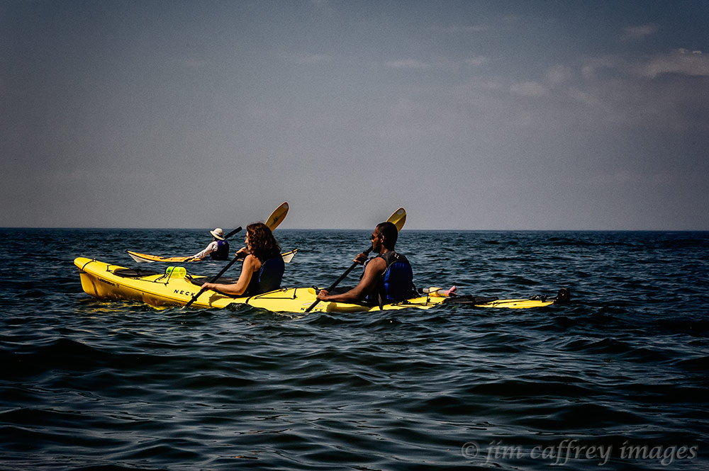
Not to be outdone by a fountain, Lake Superior, the largest body of fresh water in the world, made a lasting impression on me. It covers over thirty two thousand, eight hundred square miles. We paddled twelve of those miles in kayaks while exploring the sea caves at Apostle Island National Lakeshore.

I made this image from my kayak while my daughter’s friend Karin was paddling through a sea stack about half way through the trip. Lauren and Prasanna, her husband, can be seen to the right of the stack. In the image below, Karin’s kayak rests on a remote beach where we stopped for lunch.

After lunch and a short break, we began the trip back. I made this image of my daughter and her husband paddling their kayak with Karin and the expanse of Lake Superior beyond them. I kept my camera in a water-proof bag, so each time I wanted to make a photograph, I had to take it out of the bag and then put it back in being careful not to drop it in the lake.
Below is one last image of Karin who is an experienced kayaker as she makes her way through the deep waters of the lake with Sand Island, one of twenty-two islands in the Apostle Islands archipelago, in the distance.

Share this:

Native Dancers
The Starfeather Pow Wow at Jemez Pueblo is a popular gathering among Native American dancers. They bring with them their songs, drums, dances, and dancing regalia. The result is a sight to behold: whirling, colorful costumes, with feather, bone, and beaded accessories provide a visual symphony for locals and visitors alike.

The Starfeather Pow Wow is held each year on Memorial Day and is considered one of the highlights of the Pow Wow season. The first image shows a dancer’s feather bustle swaying with his movement during an inter-tribal dance. The singing for the dances was performed by fourteen individual drum teams from across the country. The drums provide the rhythm for the dance and the vocalizations describe the basis for interpreting the movements.

These two native beauties are from Utah and Arizona. They are dressed in colorful, traditional jingle dresses, and carry eagle and turkey feather fans. Collecting or possessing eagle feathers is against the law except for American Indians who use them for ceremonies and gatherings. To native people, feathers symbolize freedom, honor and strength.

I have lived near and known Native Americans for close to forty years, but when I saw this guy, I immediately thought: quintessential American Indian. He is Mescalero Apache, Comanche, and Kiowa, and lives in southeastern New Mexico. He told me that he’s been dancing since he was three years old.

A transplanted Lakota Sioux who now makes his home in Albuquerque, New Mexico performs in the “Golden Years” dance competition, a special category for those fifty and over.

These two “Little Warriors” captured the imagination of the crowd in their traditional “dog soldier” costumes and headdresses. Notice the “attitude” in their expressions. The hair-pipe breastplates, feather bustles, and headdresses were made by the boys’ father.
Share this:

Doorways (To The Past)
The doorways in the pueblo structures are probably the most photographed details of all the architectural features that can be found in Chaco Canyon. The first image was made in the rooms in the eastern wing of Pueblo Bonito, but I shot from the opposite end of the passages from where most people do. I like the vigas above the middle door that are visible from this perspective.
 The next two images were made at Chetro Ketl which is the second largest pueblo in Chaco Canyon. The first is a view through a window on the north side of the long greathouse wall looking at what was once an interior doorway. Beyond that is another wall and then the plaza.

The second image is looking into the west wing of the pueblo. An exterior door and two interior doors are visible.

One of the amazing things about these structures is that they were planned from the start; they were built with expansion in mind, so the bearing walls were made strong enough to support the upper stories which, in some cases weren’t built until a hundred years later.
 The last image is of a keyhole doorway which is also located in the east wing of Pueblo Bonito. I’ve researched this and have yet to find an explanation. If I had to guess, I would say that this may have been a window that was modified to connect two rooms after an addition, or perhaps it was built that way for some unknown religious or social purpose.
Share this:

Wheels In The Landscape
There was a time not so long ago when I would have gone to extraordinary lengths to exclude anything man-made from my images. But I slowly came to realize that I was being narrow-minded and losing some great photo opportunities. After removing the blinders from my artistic vision I suddenly became aware of new possibilities with subjects I would have previously rejected without a second thought.

I first came upon this car about five miles from where it now sits in the Rio Puerco Valley. I had made a second trip to its original location only to find it had been removed. I thought it odd that someone had gone to the trouble of dragging it out of the small side canyon accessible only by a two track dirt road, but then I thought that perhaps the BLM was making an attempt to tidy up the valley. It is, after all, a wilderness study area. Imagine my surprise to find the old, rusted, topless vehicle parked (for lack of a better word) in the “yard” of a tumble down adobe/rock house not far from Cabezon Peak.

I made this second image while driving through the panhandle of Texas. This whimsical installation lies along Interstate 40 east of Amarillo; I had my youngest daughter in mind when I was making the exposures. She loves VWs.


The image of the bus and the car were made along Torreon Wash near the Empedrado Wilderness Study Area near Cabezon Peak in the Rio Puerco Valley. The bus sits on rusted wheels and is full of old insulation and rat droppings suggesting that it is (was) being used as a storage shed for some nearby construction.
The car sits near an adobe/rock ruin. It is sunk to the rims in the clay soil and so its fate appears to be sealed.

This 1950s era Ford is parked in front of one of the rooms at the Wigwam Motel in Holbrook, Arizona. There are several other old vehicles parked in front of other rooms. I can’t be positive, but I highly suspect that the creators of the Disney animated movie “Cars” may have used the Wigwam as a model for the motel in the movie.

The last image was the result of accidentally being in the right place at the right time. I was driving from Albuquerque to Los Alamos by way of Santa Fe. I pulled off I-25 at the exit where the AT&SF rails cross beneath the interstate. My plan was to get down on the tracks to make an image for my Road Series (as in rail ROAD). As I was walking across the bridge above the tracks on the frontage road, I heard the whistle and soon after that I saw the Amtrak Southwest Chief come through the cut and approaching the bend in the distance.
Share this:

Autumn Glow
Sometimes the best thing about Autumn is the anticipation of the first snowfall, which often happens in early October. Well, no snow yet this year, but we have had some intense skies, and along with the falling temperatures, it sure looks and feels like we could have an early winter.

Fast forward a couple days and the temperature is back up in the 70s, normal for this time of year. I took a drive through Lake Fork Canyon to capture the aspens in their autumn coats. I made the second image at the entrance to Fogon Canyon which is a side canyon from Lake Fork. There is an old abandoned corral built up against the rock walls. I think the weathered wood compliments the color in the trees nicely.

As the sun sank lower in the sky, I reached the head of the canyon. There, on a small side road that winds through the aspen groves, I made this image of the setting sun shining through the red/yellow leaves creating a soft golden glow.

Autumn in the high country is a fleeting thing. Peak color only last for a day or two, but that’s one of the things that make it special.


